Saved Bookmarks
This section includes 7 InterviewSolutions, each offering curated multiple-choice questions to sharpen your Current Affairs knowledge and support exam preparation. Choose a topic below to get started.
| 1. |
Why is sex ratio unfavourable to women in the world? Explain any three reasons. |
|
Answer» |
|
| 2. |
Which one of the following statements about temperature is correct? |
|
Answer» Temperature decreases with height in the stratosphere. |
|
| 3. |
When was the new Industrial policy undertaken? |
| Answer» Solution :The NEW Industrial policy was UNDERTAKEN in 1991. | |
| 4. |
Which one of the following is the correct sequence of passes when one travels along the Himalayas from Kashmir to Sikkim? |
|
Answer» Zozila-Nathula-Shipkila 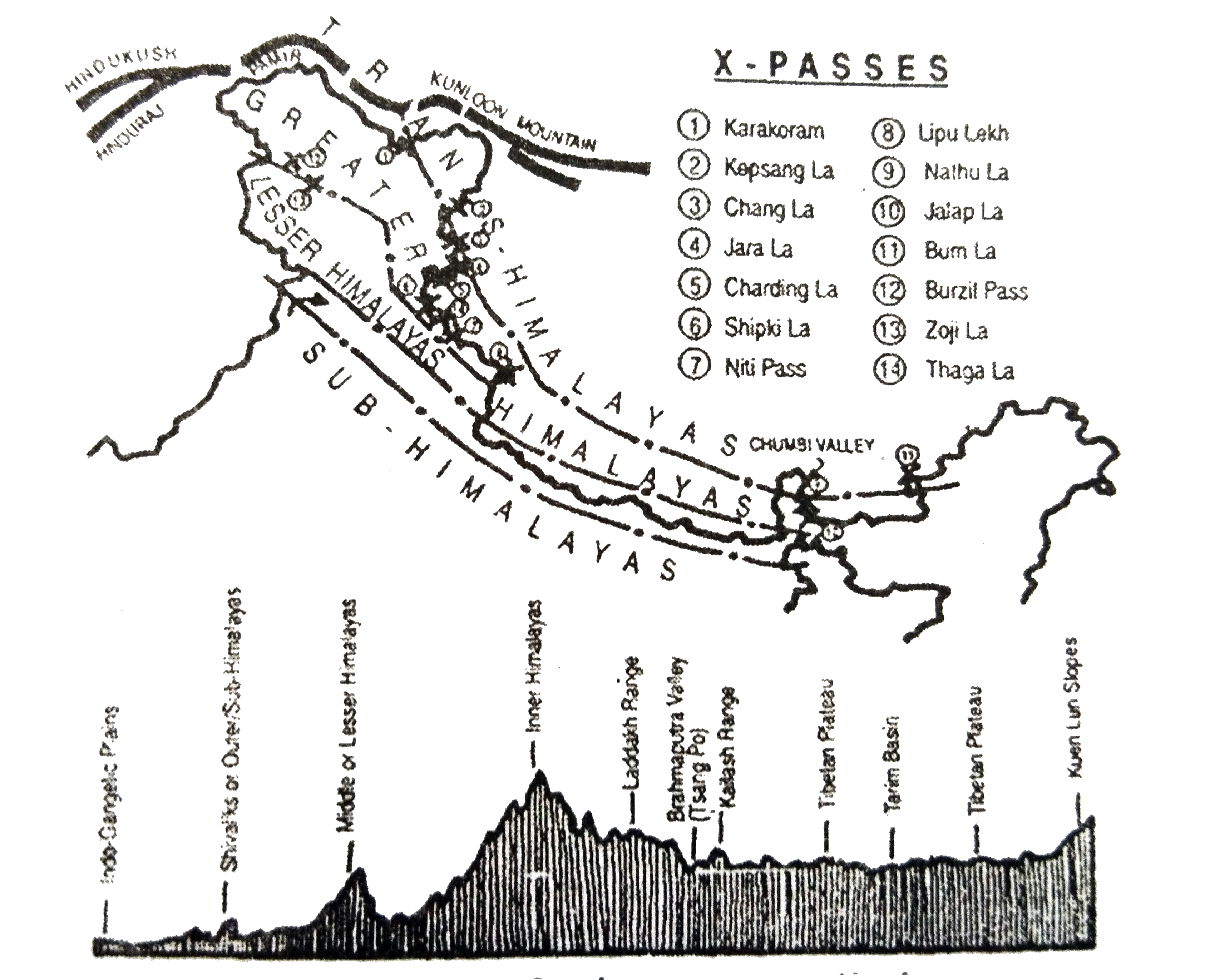
|
|
| 5. |
Which one of the following does not follow monoculture? |
|
Answer» 1. Dairy farming |
|
| 7. |
Which areas in the world have gt 200 persons per sq. km? |
| Answer» SOLUTION :NE USA, NW Europe, SOUTH, South east and East Asia. | |
| 8. |
Why the share of agricultural sector in total water used in the country is expected to decline? |
| Answer» Solution :At present the agriculture use accounts for the highest share of utilization for both ground and SURFACE water resources. The MAIN reason being that the agriculture accounts or the largest share in economy of the country, but in RECENT times the share of SECONDARY and tertiary activities have been rising in the economy. As We This in turn will REDUCE the share of the agriculture and increase the share of industrial and domestic sector in the consumption of all resources including the water resources of the country. | |
| 9. |
Which one of the following is the correct descending order of countries in terms of per capita availability of arable land? |
|
Answer» INDIA-CHINA - BRAZIL |
|
| 10. |
Which three categories have undergone increase in land use pattern? Explain why. |
|
Answer» Solution :Categories that have undergone increase in land use PATTERN are as follows: (i) The rate of increase is the highest in case of area under non-agricultural uses. This is DUE to the changing structure of Indian economy, which is increasingly depending on the contribution from industrial and services sectors and expansion of related infrastructural facilities. ALSO, an expansion of area under both urban and rural settlements has added to the increase. Thus, the area under non-agricultural uses is increasing at the expense of wastelands and agricultural land. (ii) The increase in the share under forest, as explained before, can be accounted for by increase in the demarcated area under forest , rather than an actual increase in the forest cover in the country. (iii) The increase in the current fallow cannot be explained from INFORMATION pertaining to only two points. The trend of current fallow fluctuates a great deal over years, depending on the VARIABILITY of rainfall and cropping cycles. (iv) The increase in net area sown is a recent phenomenon due to use of culturable waste land for agricultural purpose. Before which it was registering a slow decrease. There are indications that most of the decline had occurred due to the increases in area under non-agricultural use. |
|
| 11. |
Which one of the following is the driest desert of the world? |
|
Answer» ATACAMA |
|
| 12. |
Which among the following statements about the North Atlantic Drift is/are correct? I.It keeps the west coast of Northern Europe ice fre II.It is responsible for the warm air mass which interacts with the cold air mass from the Polar region and causes rainfall in Western Europe III. It meets the Labrador current near Vancouver Islandand causes dense fog Select the correct answer using the code given below |
|
Answer» I , II and III |
|
| 13. |
Which one of the following is a local wind that blows out from Siberia? |
|
Answer» Bora |
|
| 14. |
Which class of cities has the largest number of towns and cities in India ? |
| Answer» SOLUTION :Class - I cities has the largest NUMBER of towns and cities in INDIA. | |
| 15. |
Which one of the following types describes water as a resource? |
|
Answer» ABIOTIC RESOURCE |
|
| 16. |
Which one among the following is a correct sequence of production of coal in the Indian States in descending order? |
|
Answer» Jharkhand - Madhya PRADESH - WEST Bengal -MEGHALAYA |
|
| 17. |
Which one of the following towns is well-known for its aluminium industry? |
|
Answer» COIMBATORE |
|
| 18. |
Write six characteristics of the Panama Canal. |
|
Answer» Solution : Panama canal has SHORTENED the distance between eastern and western coasts of North America. This canal connects the ATLANTIC Ocean in the east to the Pacific Ocean in the west. Its economic SIGNIFICANCE are: (i) The canal is about 72 KM. long and involves a very deep cutting for a length of 12 km. (ii) It has a six lock system and ships CROSS the different levels (26 m up and down) through these locks before entering the Gulf of Panama. (iii) It shortens the distance between New York and San Francisco by 13,000 km by sea. (iv) Likewise the distance between Western Europe and the West-coast of U.S.A., and North-eastern and Central U.S.A. and East and South-east Asia is shortened. (v) The economic significance of this Canal is relatively less than that of the Suez. However, it is vital to the economies of Latin America. |
|
| 19. |
Why has gathering little chance of becoming important at the global level? Explain one reason. |
| Answer» Solution :Gathering: Products of gathering (an ACTIVITY) cannot compete in the world market as synthetic products are of better quality and available in LARGE quantities and are lower PRICED. | |
| 20. |
Which of the following are the results of EI Nino? 1. Reduction in the amount of planktons which further reduces the number of fish in the sea 2 Irregularities in the evaporation of sea water. 3. Distortion of equatorial atmospheric circulation. Select the correct answer using the code given below |
|
Answer» 1 and 2 only |
|
| 21. |
Which one of the following has caused the sex ratio of the United Arab Emirates to be low? |
|
Answer» Selective MIGRATION of MALE WORKING population |
|
| 22. |
Which one of the following pairs of properties of typical air masses is correct? |
|
Answer» `{:("Air Mass","SOURCE Region"),("Maritime EQUATORIAL:","Warm oceans in the equatorial zone "):}` |
|
| 23. |
With reference to biodiversity, which of the following statements is/are correct? 1.Species richness and high degree of endernism are important criteria for identifying biodiversity hotspots. 2 Species diversity is highest in the tropics and decreases down the poles 3 Biodiversity conservation may be in situ as well as exsitu Select the correct answer using the code given below |
|
Answer» 1 only |
|
| 24. |
Which part of India has the Kalakot tertiary coal field? |
|
Answer» Brahmaputra RIVER basin of Assam |
|
| 25. |
Which set of the following biosphere reserves in india is included in the World Network of Biosphere Reserves? |
|
Answer» Gulf Of Mannar, Nokrek, Pachmarhi and Simlipal |
|
| 26. |
Which of the following has have been declared as national waterways in India? I. The Allahabad-Haldia stretch of river Ganga II. The Sadiya-Dhubri stretch of river Brahmaputra III. The Cherla-Rajamundry stretch of river Godavari Select the correct answer using the code given below |
|
Answer» I and II only |
|
| 27. |
Which one of the following Indian States has recorded nega tive growth of population as per Census 2011 ? |
|
Answer» Manipur |
|
| 28. |
Which continent has the highest highway density? Give statistics to the fact. |
| Answer» Solution :In NORTH AMERICA, highway density is high, about 0.65 km per SQ km. Every place is within 20 km DISTANCE from a highway. Cities located on the Pacific coast (west) are well-connected with those of the Atlantic Coast (east). | |
| 29. |
1. Which areas of the world have high density of population? |
|
Answer» Solution :Fertile plains with favourable CLIMATE and highly industrialised and urbanised areas are densely populated. There are four areas where density is more than 200 persons per sq. km. They are: (a) East Asia (China, JAPAN, Korea, and Taiwan) (b) South and South-east Asia (INDIA, Indonesia, Bangladesh and Pakistan). (c ) (North-West Europe (UK, France and Germany). (d) The Northeastern Coast of North America |
|
| 30. |
Which one among the following is not a factor that affects direction of wind? |
|
Answer» PRESSURE gradient |
|
| 31. |
Which sector of economy accounted for the highest percentage of India's total value of exports in 2003-2004? |
| Answer» SOLUTION :Industrial/manufacturing SECTOR. | |
| 32. |
Which one of the following is known as a zone of sharp salinity change in the vertical section of ocean? |
|
Answer» Thermocline |
|
| 33. |
Which one of the following is the correct descending order of Indian States in terms of sex ratio as per Census 2011? |
|
Answer» Mizoram-Manipur- Tripura-Meghalaya 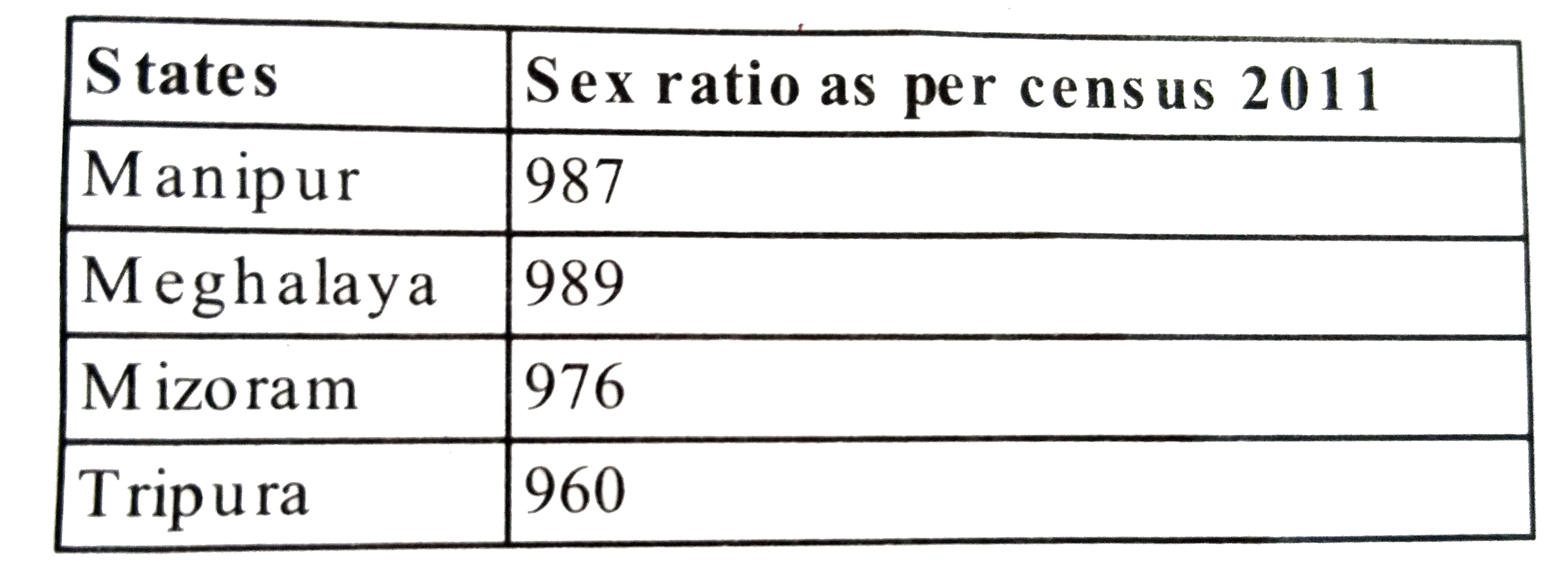
|
|
| 34. |
Which of the following statements characterize convectional rainfall? 1.It occurs daily in the afternoon in the equatorial regions 2 It is of very short duration 3.It occurs through Cumulonimbus clouds Select the correct answer using the code given below |
|
Answer» 1,2 and 3 |
|
| 35. |
What percentage of cropped area in India is under rice & wheat cultivation? |
| Answer» SOLUTION :25% of the total cropped area is under rice, and 14% of the total cropped area is under wheat cultivation in India. | |
| 36. |
Which factors help in determining types of settlement ? |
| Answer» SOLUTION :Types of settlement are DETERMINED by the EXTENT of the BUILT up area and INTER house distance. | |
| 37. |
Why is hydrolysis an effective form of chemical decomposition of bedrock in humid tropics? 1.Humid tropics experience high temperature andhumidity 2.There is high diurnal range in temperature. Select the correct answer using the code given below |
|
Answer» 1 only |
|
| 38. |
When are the matic maps drawn? |
| Answer» Solution :Thematic MAPS, graphs and DIAGRAMS serve a useful purpose in providing a COMPARISON betwene the internal variations within the DATA of different characteristics represented. | |
| 39. |
Write a note on railways in Asia. |
| Answer» Solution :In Asia, rail network is the most dense in the thickly populated AREAS of Japan, China and India. Other countries have relatively few rail routes. West Asia is the least developed in rail facilities because of vast deserts and sparsely populated regions. One of the most important railways of Asia is trans-Siberian Railways, a MAJOR rail route of Russia which runs from St. Petersburg in the west to Vladivostok on the Pacific Coast in the cast passing through Moscow, Ufa, Novosibirsk, Irkutsk, Chita and Khabarovsk. It is the most important route in Asia and the longest (9,332 km) double-tracked and electrified trans-continental railway in the world. It has helped in opening up its Asian region to West European markets. It runs across the Ural Mountains OB and Yenisei rivers. Chita is an important agro-centre and Irkutsk, a fur centre. There are connecting links to the south, namely, to ODESSA (UKRAINE), Baku on the Caspian Coast, Tashkent (Uzbekistan), Ulan Bator (Mongolia), and Shenyang (Mukden) and Beijing in China. There is a proposal to build Trans Asiatic railway linking Istanbul with Bangkok via Iran, Pakistan, India, Bangladesh and Myanmar. | |
| 40. |
Which of the following statements is/are correct? 1 The tropical cyclones of China Sea are called typhoon's The tropical cyclones of the West Indies are calledtornadoes 3.The tropical cyclones of Australia are called willy willies 4.Formation of an anticyclone results in stormy weather condition. Select the correct answer using the code given below |
|
Answer» 1,2,3 and 4 |
|
| 41. |
Which one of the following is not an area of sparse population? |
|
Answer» 1. The Atacama |
|
| 42. |
Which states have surface water in the form of lagoons and lakes? For what purpose is it used? |
| Answer» Solution :The states LIKE Kerala, Odisha and West Bengal have vast SURFACE water resources in these lagoons and lakes. Although, water is generally BRACKISH in these water bodies, it is used for fishing and IRRIGATING certain varieties of paddy CROPS, coconut, etc. | |
| 43. |
What role do manufacturing industries play in development of an economy? |
| Answer» Solution :Manufacturing industries provide employment to LABOUR force. By the sale of their output, ECONOMY GETS momentum. It provides base for the development of primary and tertiary sectors. THEREFORE, they act as barometer of economic development of a country. | |
| 44. |
Why is West Asia the least developed in rail facilities ? Explain one reason. |
|
Answer» Solution :Reasons for Least development in rail facilities in West Asia - (i) Vast desert area (II) SPARSELY populated region It is not EASY to lay railway lines in desert SANDS. Further, railways are built to secure large populations. Since West Asia has a sparse population, other modes of transport are more suitable. |
|
| 45. |
1. Which are the least spoken language of india ? |
| Answer» SOLUTION :KASHMIRI and SANSKRIT LANGUAGES. | |
| 46. |
Which one of the following is NOT a tributary of Indus River? |
|
Answer» Beas |
|
| 47. |
Which agency brings out the Human Development report? |
| Answer» SOLUTION :United Nations-Development Programme publishes human development report ANNUALLY since 1990. | |
| 48. |
Which one of the following is not a push factor? |
|
Answer» WATER shortage |
|
| 49. |
Which one among the following is nearest to the Tropic of Cancer? |
|
Answer» Patna |
|
| 50. |
Which of the following features is the product of vulcanicity? |
|
Answer» FOLD Mountain |
|